
Improving How You Move Along State Road 32
Today, in our fast-paced lives we rely on efficiency and accessibility to get to where we are going. Whether it’s our morning drive to the office or a mad dash to batting practice– State Road 32 connects people to places, and those places fuel our purpose each day. If we can’t get to where we’re going easily and safely, it impacts us.
Join us as we host a public hearing on June 10, 2026 to update the public on this project.
Project Need + Location
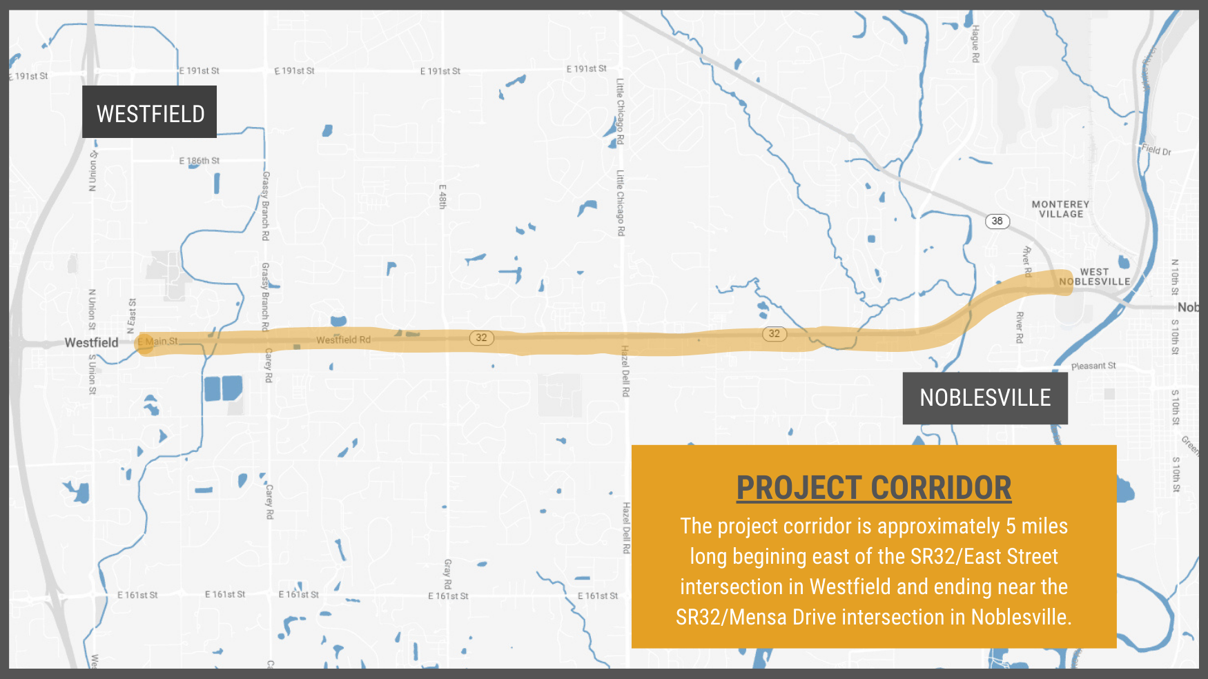
The State Road 32 corridor between Westfield and Noblesville has seen rapid growth in development and traffic in recent years. With this increase in growth the incidence of congestion and traffic crashes has also increased. To address this, the Indiana Department of Transportation (INDOT) has initiated a project (Improve to Move 32) to improve this corridor, an important connector in Hamilton County. This project is expected to begin east of the SR32/East Street intersection in Westfield and end near the SR32/Mensa Drive intersection in Noblesville,for a total distance of five miles.
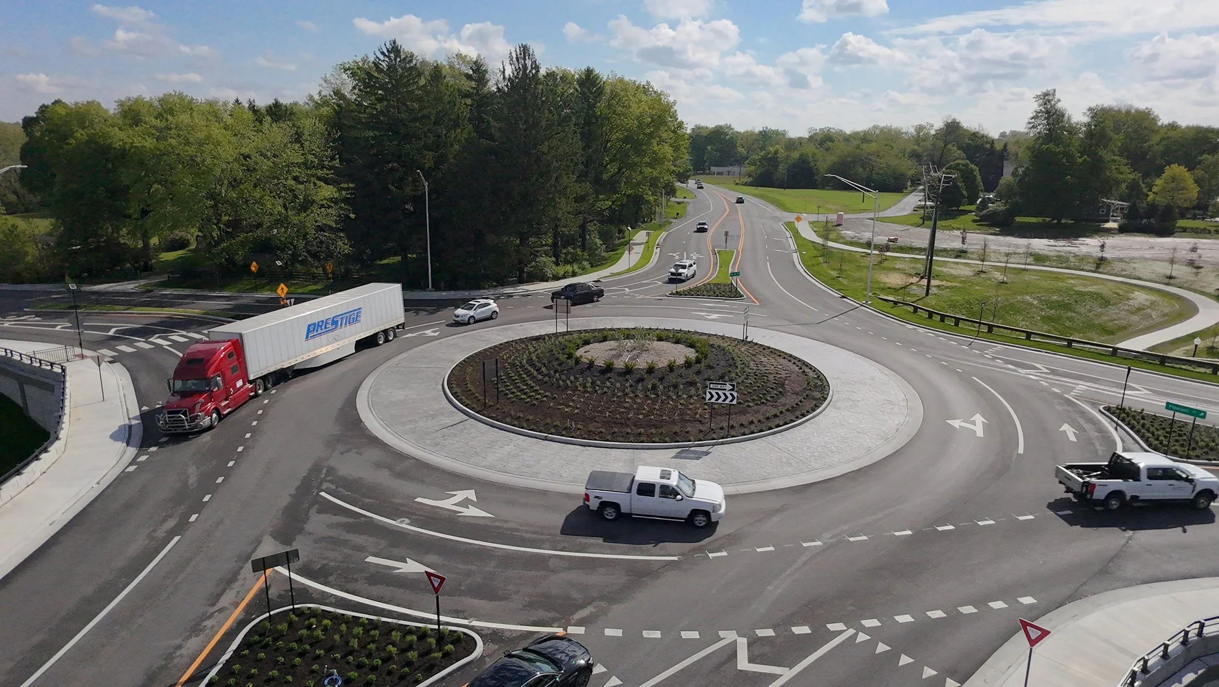
The project design proposes roundabouts at these key intersections:
Carey Road/Grassy Branch Road
Gunther Boulevard
Shady Nook Road
Moontown Road/Gray Road
Pebble Brook Boulevard / Hazel Dell Elementary School
Hazel Dell Road / Little Chicago Road
Mill Creek Road
Hague Road / Pleasant Street Extension (Completed by the City of Noblesville)
-
There are approximately 110 crashes annually along this corridor due to congestion and lack of alternate lanes. 70% of these crashes are rear-end incidents. Improving this corridor with alternate turn lanes and roundabouts will improve traffic safety.
-
The traffic back-up and time to travel this corridor at peak times of the day continues to increase. Currently, the estimated time is 7-8 minutes, with an increase to 12-19 minutes in the next 20 years. With a redesign of this roadway, the goal is to achieve a travel time that is less than 10 minutes during the busiest times of the day.
-
With the new proposed design for this corridor, pedestrian paths and access are a key feature. Specifically, an 8’ asphalt path to exist along both sides of the roadway. There will be a grass buffer between the path and roadway, where space permits. The pedestrian access will also connect to existing walking/biking paths in Westfield, Noblesville, and the Midland Trace Trail.
This Project Will Help:
Project Timeline
Improve to Move State Road 32 is a multi-phased project. Here’s a snapshot of the timeline to date.
2022-2024| Public Outreach, Preliminary Design *Complete
2025-2026 | Public Outreach, Final Design, Land Acquisition,
and Permitting *In Progress
2027-2028| Utility Relocations
2028-2029| Construction

Ongoing Project Communication
We’re Committed to Helping Residents and Businesses Understand the Scope of this Project.
Major road construction projects are complex, and it’s critical for the community and its stakeholders to have access to information. The Improve to Move State Road 32 Project Team has met with dozens of residents and business owners in one-on-one settings. They have also hosted annual public information meetings since spring of 2022. As work continues on this project, you are invited to request a meeting to ask questions and learn more.
Other Local Projects
There are other local projects in Hamilton County that may impact your daily routes.
There are active road construction projects throughout our county. Projects are being coordinated to ensure our construction phasing and detour routes will maintain local mobility in the area. Helpful tip: If you’re unsure of the best route to take to your destination, apps like Google Maps, Apple Maps, and Waze are updated regularly and can give you the fastest route to avoid construction areas. Here’s a list of local projects underway (click to learn more):


